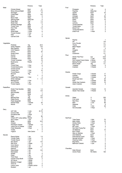
 Double click for a full size shopping list.
Food
Provisioning
OK so we're going to be offshore for at least 3 weeks and neet to cater for 4 weeks, 5 people, plus emergency rations, how do you plan for that?? We had plenty of books with good advice on how long different foods last, and we could all cook, but 3-4 weeks for 5 people is a lot of food!
We decided the best method was to actually plan the menu for every day. With 5 crew, we would all do 4 lunches and 4 main meals, that should get us through 20 days, or the planned timetable for the trip. We would also add nearly 2 weeks worth of emergency food, eg packet pasta and tinned meals. Of course we were going to catch plenty of fish to supplement the rations, but we decided not to count these in the planning until they were in the boat!
Once we'd done the food, we moved onto liquids, eg drinking water, tap water, milk, Fruit Juice, wine and beer. This took some debate, as some crewmembers wanted more water, others wanted more wine and beer! My opinion was that we had enough water, but wine and beer are much cheaper in the Canaries than in the Caribbean, hence I added a personal supply of 50 bottles of red wine to be stowed away!
We created a list of sauces, spices, cereals, crisps, chocolate and other items we thought would be good and added them to the shopping list.
Then on to non food items, toilet rolls (essential), cleaning products, bin liners etc. Much less debate on this one!
The Shopping List
 Double click for a full size shopping list.
With the list created, the girls made several trips to the supermarket and had it delivered, by van or taxi to the beach or marina so we could load up the tender and get it to the boat. Even getting the food to the boat was a challenge as we were at anchor, I heard of one boat losing a full serrano ham (about 100€ worth) by dropping it as they were passing it into the boat!
The Menu for the crossing
We all expected the food to be a bit more basic than normal during the crossing, limited fresh vegetables and cooking whilst sailing, must make life harder! When we first put all the meals together into a menu, we were in for a big shock! How we managed to come up with such a varied menu and still be able to cook it after 3 weeks was beyond me!
The Planned Menu:

Our planned food was good enough for most people, but once we supplemented it with fresh fish, we were living in luxury! We swapped out some of the chicken and meat dishes for fresh fish (mostly Dorado, but some Tuna) and extended the menu by enough days to reach Barbados without suffering many packet pasta meals!
Download the Atlantic Food Spreadsheet with all the details for the above food and water etc.
Water
We need 2 types of water onboard, tap water in the tanks for cooking, washing, day to day use, then bottled water for drinking.
The bottled water was easy (apart from a discussion on quantity). Based on 2 litres of water per person per day, we needed 10 litres per day, hence approximately 200 litres for a 3 week crossing. Adding more drinking water would be good, but I was keen to get the 200 litres onboard and stowed before we bought maybe another 100 litres!
Tap water in the tanks was a problem. The boat has 2 water tanks, each holding 250 litres of water. When I was living alone on the boat, the tanks would last me about 6 weeks, but this included going ashore daily and eating out 3 or 4 times a week. Even then, with 5 people onboard, the water in the tanks would only last 9 days! We could stock up on extra water, either adding extra water tanks, or just filling the biggest containers we could find. We also needed to do whatever we could to conserve water, so the following ideas were followed:
Cooking potatoes cooked in totally sea water.
Carrots cooked in 1/3 sea water (I tried with all sea water and ended up emtying my stomach!)
Pasta and Rice 1/3 sea water.
Soups and sauces, mostly tap water.
Washing up all in sea water.
Washing hands after using the toilet with baby wipes.
Showering using a solar shower, maximum 1 each per week.
Washing daily by swimming in the sea or using sea water in a bucket.
I switched off one of the water tanks so we would know when we were down to half way. We could easily forget to check the water guage if not!
We ended up by taking an additional 50 litres of water in 5 litre containers and using these for the showers etc.
This was probably my biggest worry for the trip, yet we did really well. We arrived in Barbados, with about ???? Litres of water in the tanks even though we had increased the fresh water allowances in the last few days.
Stowing it all away
This was easier than we had expected, as Maggie had swapped boats, we had a spare double cabin, so we chose the one next to the galley and it became the store room. I had moved my windsurfer in there and stacked it against the outer wall, but we had the entire bed, plus the space underneath for food.
As the Blue Dolphin is a catamaran, we also had loads of spare stowage available elsewhere in the boat, so stowing 150 litres of drinking water in a locker in the cockpit was easy. The 50 litres of bottled tap water fitted under a drain in the cockpit floor.
My bottles of wine and beer fitted easily under the seats in the saloon. We ended up stowing everything away and having space left over where we could have bought more if we wanted! One extra person would have made this a lot harder, so in future I would always plan on keeping a spare cabin just for food on a long voyage.
Fuel
We have 2 * 75 litre fuel tanks, the Port one supplying the port engine only and the starboard one supplying the starboard engine, plus the generator. I was confident it would not be enough fuel! If we had perfect weather, we would be ok, only using the generator to recharge the batteries and boost the freezer. We bought an additional 4 * 22 litre fuel containers and filled them with diesel before setting off! We were proved right, when we had to motor for 57 hours during the first week. This hit the diesel in the tanks and forced us to pour 22 litres into each. We would save the last 44 litres of spare diesel until we needed it for the generator or the final arrival at Barbados. The winds became more consistent as we progressed so we were able to sail and only use diesel for the generator for most of the rest of the trip. I had expected fairly consistent winds for the whole crossing, but we set out a bit early for the trade winds to develop and experienced the effects of Tropical Storm Delta which moved from the Azores over to the Canaries, but affected the weather across most of the SW Atlantic.
I also hadn't realised how long it would take to freeze all the meat in the freezer, this was critical to the journey, so we spent the first couple of days with the Port Engine running as it has the mechanical compressor attached. The Freezer either runs off the Port engine, or from 220v which means running from the inverter and recharging the batteries with the generator.
Night Watches
We were happy with the daytime as there was always someone up and alert during the day. We had an unwritten rule that is everyone else had gone to sleep, the last one up stayed up until someone replaced them. Night shifts had to be organised, otherwise they wouldn't have happened, so we had a chat and came up with a rota:
| Day 1 | Day 2 | Day 3 | Day 4 | Day 5 | |
| 18:00 - 21:00 | Steve | Patty | Graham | Natalie | Floris |
| 21:00 - 00:00 | Floris | Steve | Patty | Graham | Natalie |
| 00:00 - 03:00 | Natalie | Floris | Steve | Patty | Graham |
| 03:00 - 06:00 | Graham | Natalie | Floris | Steve | Patty |
| 06:00 - 09:00 | Patty | Graham | Natalie | Floris | Steve |
Working with this rota gave us 3 easy nights, followed by 2 harder ones. 18:00 - 21:00 was treated as a day off. 21:00 - 00:00 usually only meant an hour or so on watch alone as others would stay up. 06:00 - 09:00 was one of the most popular watches as you saw the sunrise and you had already had 6-8 hours of sleep so no problem getting up. That only left 00:00 - 03:00 and 03:00 - 06:00 as the harder watches.
Weather
Weather was going to be critical as part of the planning, so we obtained every bit of information we could get before setting off.
Internet sites
www.weatheronline.co.uk This gave some great wind reports for up to a week ahead, so we could get an idea of direction and strength for the start of the trip. Obviously the later forecasts would be a bit less reliable once under way!
Some Samples from Weatheronline,.co.uk
| 19th November 2005 00:00 | 20th November 2005 00:00 | 21st November 2005 00:00 |
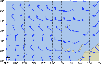 |
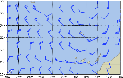 |
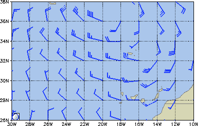 |
The US NOAA website provided great maps, the same ones we would later be receiving by SSB weather fax from Boston and New Orleans. getting these was also easy, just send an email and wait for the files to be emailed back! Download the text file with sample emails.
Sample NOAA Charts, click to enlarge.
SSB Radio Voice Forecasts
I have a SEA 225 SSB transceiver onboard, and whilst I am not licensed I cannot transmit, but it was perfect for receiving weather forecasts and faxes.
Radio France International 21645Khz 11:40 UTC (UTC is the same as GMT) - Excellent forecasts for the entire crossing (if you speak French!)
Transatlantic Mobile Maritime Net (Trudi 8P6QM from Barbados) 21400Khz. - General weather chat at 13:00 UTC and English translation of the France International forecast at 12:30 UTC.
Southbound II (Herb's Net) Herb Hilgenberg GX498 from Canada 12359Khz - Detailed weather for individual boats as they cross. Boats radio their current position, wind and barometer readings and Herb gives excellent advice about routes etc. In November he was really busy and must have been on air for over an hour each day. Listen early as he works through the regions, eg East to West crossings from Africa first, followed by North America to Bermuda then down to the Caribbean.
SSB Weather Faxes
The SSB was connected to my laptop using a simple microphone lead, wired to the speaker output on the SSB, 5minutes with a soldering iron and job done! I then used some software I had bought last year, which translates the fax signals (and others) to faxes on the screen and saves them as gif files. Mscan Meteo from www.digitalyacht.co.uk worked well and I would recommend it unless there is freeware out there which I haven't found yet!
Cathy from Claudia B gave me a great document for sailors with SSB radios, the frequencies and schedules for the transmissions all around the world! It proved to be invaluable as I was able to bring in weather maps and forecasts from Northwood UK, Hamburg, Boston and New Orleans. The version I used is here for download or you should be able to get the latest one from the NOAA website at http://www.nws.noaa.gov/om/marine/home.htm
The quality of the weather faxes improved as we progressed, Northwood had been great when we set off, but only covered as far as 26°N so was only useful for the first 120 miles or so. We then used Offenbach (Hamburg) which went a bit further south but not much. As soon as we were able to reach Boston and New Orleans, we had better faxes, they covered the entire Atlantic, with Boston going down to 20°N and New Orleans going right down to the Equator. We found that we had intereference from the generator and inverter when using the SSB for faxes, so made sure they were off whilst we downloaded.
Here are some samples of the weather faxes we received.
Northwood
Boston
New Orleans
Navigation
Ships Log
We kept a full ships log with updates every hour for the first 2 days, then every even hour for the remainder of the crossing. Anything of interest (eg fish caught) was added to the log. I also maintained a spreadsheet with our positions at midday each day, so we could estimate our arrival date and total mileage of the crossing. After the first couple of days with no wind, we were looking at a crossing time of over 40 days, but as the wind increased, we dropped below 30, and would hopefully finish in about 20 - 22 days. Not the fastest crossing, but the wind wasn't really on our side for the first week!
Ships log daily positions
| Date | Time | Lattitude | Longitude | Distance over Ground | Average | Distance Made Good | Average | Distance | Estimated | ||||
| Degrees | Minutes | Degrees | Minutes | Daily | Total | Speed nm | Daily | Total | Speed Made Good | Remaining | Days Remaining | ||
| 18/11/2005 | 20:30 | 28 | 3.3 | 15 | 21.9 | 0 | 0 | 0 | 0 | 0 | 0 | 2800.9 | |
| 19/11/2005 | 12:00 | 27 | 24.36 | 15 | 45.54 | 45.6 | 45.6 | 1.9 | 34.6 | 34.6 | 1.4 | 2766.3 | |
| 20/11/2005 | 12:00 | 25 | 49.38 | 16 | 22.5 | 101.9 | 147.5 | 4.2 | 63.2 | 97.8 | 2.6 | 2703.2 | 42.8 |
| 21/11/2005 | 12:00 | 24 | 41.31 | 17 | 15.75 | 86.4 | 233.9 | 3.6 | 69.6 | 167.4 | 2.9 | 2633.5 | 37.8 |
| 22/11/2005 | 12:00 | 24 | 5.06 | 18 | 49.25 | 100.3 | 334.2 | 4.2 | 99.7 | 267.1 | 4.2 | 2533.8 | 25.4 |
| 23/11/2005 | 12:00 | 23 | 28.12 | 20 | 25 | 102.6 | 436.8 | 4.3 | 102 | 369.1 | 4.2 | 2431.8 | 23.8 |
| 24/11/2005 | 12:00 | 22 | 41.18 | 22 | 3.6 | 109.2 | 546 | 4.6 | 107.2 | 476.3 | 4.5 | 2324.7 | 21.7 |
| 25/11/2005 | 12:00 | 22 | 3.99 | 23 | 24.24 | 88.8 | 634.8 | 3.7 | 87.2 | 563.5 | 3.6 | 2237.5 | 25.7 |
| 26/11/2005 | 12:00 | 20 | 50.15 | 25 | 19.76 | 137.1 | 771.9 | 5.7 | 129.2 | 692.7 | 5.4 | 2108.3 | 16.3 |
| 27/11/2005 | 12:00 | 19 | 34.41 | 27 | 45.85 | 164.6 | 936.5 | 6.9 | 158.5 | 851.2 | 6.6 | 1949.7 | 12.3 |
| 28/11/2005 | 12:00 | 19 | 17.33 | 29 | 43.3 | 118.7 | 1055.2 | 4.9 | 118.5 | 969.7 | 4.9 | 1831.2 | 15.5 |
| 29/11/2005 | 12:00 | 18 | 50.7 | 31 | 0.96 | 82.1 | 1137.3 | 3.4 | 81.4 | 1051.1 | 3.4 | 1749.9 | 21.5 |
| 30/11/2005 | 12:00 | 17 | 49.05 | 32 | 59.72 | 133.8 | 1271.1 | 5.6 | 127.9 | 1179 | 5.3 | 1621.9 | 12.7 |
| 01/12/2005 | 12:00 | 17 | 3.32 | 35 | 10.5 | 138.5 | 1409.6 | 5.8 | 136.4 | 1315.5 | 5.7 | 1485.5 | 10.9 |
| 02/12/2005 | 12:00 | 16 | 38.03 | 37 | 1.22 | 113.6 | 1523.2 | 4.7 | 113.3 | 1428.7 | 4.7 | 1372.2 | 12.1 |
| 03/12/2005 | 12:00 | 16 | 12.16 | 38 | 42.2 | 104.2 | 1627.4 | 4.3 | 103.6 | 1532.4 | 4.3 | 1268.6 | 12.2 |
| 04/12/2005 | 12:00 | 15 | 56.6 | 40 | 25.67 | 104.6 | 1732.1 | 4.4 | 104.6 | 1637 | 4.4 | 1163.9 | 11.1 |
| 05/12/2005 | 12:00 | 15 | 42.1 | 42 | 41.73 | 136.8 | 1868.9 | 5.7 | 136.7 | 1773.7 | 5.7 | 1027.2 | 7.5 |
| 06/12/2005 | 12:00 | 15 | 4.39 | 45 | 11.96 | 154.9 | 2023.8 | 6.5 | 153.9 | 1927.7 | 6.4 | 873.3 | 5.7 |
| 07/12/2005 | 12:00 | 15 | 6.03 | 48 | 16.9 | 184.9 | 2208.7 | 7.7 | 182.8 | 2110.5 | 7.6 | 690.4 | 3.8 |
| 08/12/2005 | 12:00 | 15 | 9.61 | 51 | 36.25 | 199.4 | 2408.1 | 8.3 | 194.9 | 2305.5 | 8.1 | 495.5 | 2.5 |
| 09/12/2005 | 12:00 | 14 | 25.25 | 54 | 20.9 | 170.5 | 2578.6 | 7.1 | 170.4 | 2475.9 | 7.1 | 325.1 | 1.9 |
| 10/12/2005 | 12:00 | 14 | 1.76 | 57 | 16.9 | 177.6 | 2756.2 | 7.4 | 176.2 | 2652.1 | 7.3 | 148.9 | 0.8 |
| 11/12/2005 | 10:30 | 13 | 15.77 | 59 | 38.69 | 149.1 | 2905.2 | 6.2 | 148.5 | 2800.5 | 6.2 | 0.4 | 0 |
| Average | 130 | 5.4 | 125.7 | 5.2 | 0 |
Download the complete log with our position every 2 hours for the crossing.
GPS systems
The boat is fitted with a B&G Chartplotter which makes life so much easier for navigation. If the wind was behind us all the way, I could click in 3 places, inserting waypoints and then just press "Track" on the autopilot and the boat would steer itslef all te way to Barbados. It would even allow for currents and leeway from the wind and counter steer to allow for these! The only problem was that the B&G Chartplotter had packed up before Gibraltar!
Garmin Streetpilot - I had a Garmin streetpilot which I used in the Landrover and Jeep back home. I'd brought it with me as an emergency GPS and we had to use it when the B&G packed up. It was surprisingly good, even though it was meant for finding routes along roads, the coastline maps included also had most of the harbours along the Spanish coast and into Gibraltar. Plugged into a lighter socket it had become the boats main navigation system for a few weeks.
Garmin etrex Vista C - Graham had brought his with him as they were touring for a year so we pulled it out and used it as a secondary GPS. The etrex was for general navigation and allowed us to select nautical miles and other settings more appropriate to sailing than the streetpilot. It was also quite economical on batteries, using rechargeables which only needed swapping once a day or so.
Garmin GPSMAP 76s- Floris had brought his Garmin with him also. It was twice the size of Graham's, making the screen easier to read when viewing the maps and had a few more features, but also making it much heavier and it would eat batteries in comparison. Luckily it used the same sockets as my Streetpilot so we were able to plug it into12v.
Connecting the handheld GPS to the Autopilot - We had a couple of data cables, one with power and one for connecting to the PC, but none of the cables had power and data combined. The chandlery in Las Palmas were really helpful and obtained the cable we needed next day! 5 minutes of soldering and we were able to connect either Floris' or my Garmin GPS' to the boats NMEA system and hence into the autopilot. Floris had bought the cable and a spare serial plug, I just had to solder up the wires and make the lead. Whilst researching the correct pins for the serial cable, I came across the manual for the B&G chartplotter. 10 minutes of reading the manual and I found out how to perform a factory reset on it and lo and behold it was working again! We now had fully functional chartplotter, plus 3 handheld GPS', Result !!!!
Celestial Navigation
I had bought a sextant last year after completing the purchase of the boat, but I had no idea how to use it! I bought a couple of books, one was a waste of time, the other was quite good and made sense, but didn't relate to the chart tables I had also needed! In the end, I followed the examples in the Reeds Astro Navigation Tables book and created my own spreadsheets which simplified the calculations significantly!
Within a week at sea, all the crew had succesfully calculated our position by sextant to within 20 miles, which I thought was pretty good going for amateurs! I now understand the principles of Celestial Navigation and have progressed from noon fixes on the sun, to star sights of Polaris and will be studying more to work out the formulas for other stars in the future.
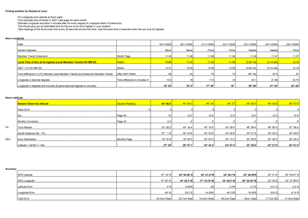 Click on the image to see the detailed table, or download
the full Excel Spreadsheet
PC Software
I have a fair selection onboard, several navigation programs including Fugawi, CMAP, Autoroute and Google Earth! Yes those last two are serious, Autoroute is great for the areas where you don't have the latest charts, not perfect for coastal navigation, but when crossing the Atlantic, not bad! Google Earth had only come out this year, but gives satellite images of places and really great fly by views of the world! Google Earth needs to be online for the up to date info, but if you get Internet access somewhere, fly over the areas you will be sailing to, you can then view them from offline cache when in Mid Atlantic!
What we had to fix!
Gas Leak! - I know that sounds bad, but it was just a loose connection near the gas bottles. They are outside of the boat, in a forward locker near the anchor and one of the connections was just loose enough that gas was running out much faster than normal. 10 minutes with the spanners and job done!
Generator - I've had a few intermittent problems with the generator, when it's running it's great, but every few months it just fails to start. To fix it you normally remove and reseat the relays in the control box and move a few wires around! This time it was not to be, so I removed the whole relay box and found a broken connector! This must have been the cause of the problems all year, so clean the wires, crimp a new connector on and it started first time. No further problems since.
GPS Chartplotter - As mentioned earlier, it failed soon after leaving the Mar Menor. "Invalid fix - Distance too Far" was the error message and it would not allow us to press anything to clear it. As my navigation charts finished at the Mar Menor on the West side, I thought it might be to do with that, and I couldn't seem to clear it as I couldn't access the menus. One month later after reading the manual, I found out how to access the engineers menu and perform a factory reset, instantly the chartplotter was fully functional again! When we get to the Caribbean I may even see if I can get detailed charts in the right format for it.
Sew the sails - We'd done a few thousand miles getting to the Canaries with some fairly strong winds so it wasn't too much of a surprise when the jib opened up on a seam. Only 6 inches or so, but enough to furl it in and initiate repairs. We spent a few hours repairing the split seam and also checking the rest of the jib and sewing over any worn stitching we could find. On our second day at sea, we spotted another seam opening up, this time in the mainsail and right near the top. We dropped the sail and sewed it back together, we have a reasonable technique now and were confident we could perform neat hand stitching at sea if we needed to.
Autopilot / Wind Vane Seatalk connection - The Autopilot had started playing up on the way to the Canaries, usually reliable, then just when you didn't want it to happen "Seatalk Failure" and "No Pilot" messages and you had to grab the wheel and sit there! We had isolated the problem whilst in the canaries and traced it to the wind meter! All the instruments are connected together on a SeaTalk bus and if we disconnected the wind meter, all was reliable, plug it in again and we lost the pilot. We had left the wind meter with only one SeaTalk connection for a few days, this gave it power but stopped it communicating with the autopilot, and had no further problems. After a few days at sea, I took another look at the wind meter, all the wires were good, I checked the continuity from the connectors to the circuit boards and couldn't find a problem, so we reconnected it again, no further problems so far, but we know what to disconnect if the autopilot fails again!
Spinnaker Halyard Chafing - I had bought a new spinnaker halyard before leaving Mallorca. I haven't got a spinnaker, but we would be using this halyard to hoist the second foresail as we expected to be sailing downwind most of the way to Barbados. The halyard worked fine when sailing downwind, but if we used the genoa on more of a reach, it was chafing the halyard on the pulley as it entered the mast. I bought a new block in Las Palmas and was hoisted up the mast again. I stuck the fitting to the mast with West Epoxy, this is like fibreglass but really really strong adhesive. Left it for about 4 hours, then I was hoisted up again to drill and rivet the fitting. Having fitted the new block about 8 inches below the pulley, it should keep the halyard in line and prevent chafing. After a few days at sea and the first time we used the genoa on this halyard, we brought the sail down and again the rope was nearly worn through! We had been sailing too close to the wind again, so we decided we would only use this halyard if we were beyond 120° from the wind. We also fitted some hose over the halyard to prevent it chafing on the roller furling of the jib.
Spinnaker Halyard Dropping inside mast! - After all the problems with chafing, we had been forced to shorten the halyard twice and redo the eye whipping on the end. One morning I had just replaced Graham on the watch and within 2 minutes the sail suddenly blew out and dropped between the hulls. A quick knock on his door and go and retrieve the sail. The whipping had failed and the halyard had dropped back inside the mast! The only way to fix this is to pull the rope out and drop it again from the top. Someone had to go up the mast whilst at sea and lower it down. The alternative was to leave it until we arrived in Barbados and do it there, which do you think we chose?
| Home Page | Caribbean Crossing Main Page | Previous Page | Next Page |